White County, Illinois
Maps
Just a few map images I have
collected.
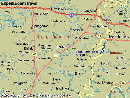
This map is from Expedia.com. Highways 14 and 141 have been
omitted,
as are the county borders, but it has several old villages
listed.
Two notable exceptions are Epworth, located south of Carmi, and Rising
Sun, more commonly called Dogtown, south of Emma. The large Marshall
Ferry
cemetery is located there, and sometimes the area is called Marshall
Ferry.
Epworth is located on Big Prairie and Big Prairie Church and cemetery,
where some of the first settlers in the county came before 1810.
You can see from this map why the area economic development agency
calls
itself "Wedge", for the triangle formed between the two north-south
highways
and the interstate.
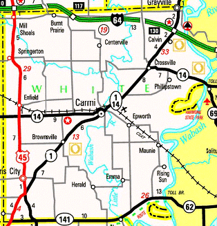
This map is from the IDOT website, where there is an interactive
version
of the official state highway map. It does have a better view of
county roads and boundaries but I cut off part of Norris City, all of
Gossett,
and the top of Grayville.
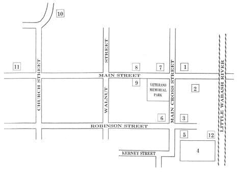
This is a walking tour map of Carmi, which I found at the City of Carmi
site. Here is the legend:
1. White County Courthouse, built 1883.
2. "The Castle", common name of James Robert William home, built
1896, and listed on the National Register of Historic Places. Now a
private
residence, also used for display of antique furniture for sale.
3. Webb Hay house, built in 1876 for Carmi mayor and banker Frank
E. Hay. His in-laws were the Webb family, which includes State Senator
Edwin B. Webb. Now used as a private residence but open for occasional
private dinners.
4. Old Graveyard, which was the final resting place for most
Carmi citizens who died before the 1890s', when Maple Ridge cemetery
was
established. The last burial was of Miss Mary Jane Stewart in
1966.
5. The Matsel Cabin, owned by the White County Historical
Society.
This structure was built in approximately 1853 about two miles SW of
Carmi
and moved to town in 1996.
6. The Robinson-Stewart House, which originally was built in
1814 as John Craw's log cabin. Remodeled several times by US Senator
John
Robinson, who served from 1831 to 1843. His granddaughter, Miss Mary
Jane
Stewart, gave the house and contents to the Historical Society in
1966.
The property is on the National Register.
7. I guess this is for the Carmi City Hall and Light and Water
office. This structure was built in the 1950s by Mayor Brandt,
and
originally had a jail in the basement and fire station in back. Not an
historic structure in my mind, but it is also home to the Carmi Chamber
of Commerce.
8. L. Haas Store Museum, built as the Bankrupt Store in 1896
by the Storms family for Louis Haas, a Jewish German immigrant.
It
was purchased by the Historical Society in 1992 to house its
ever-growing
collection of artifacts. It is on the National Register.
9. The Ratcliff Inn, built in 1828 by James "Old Beaver" Ratcliff,
first White County Clerk/Treasurer. The federalist structure was close
to demolition when the White County Historical Society purchased it in
1960 with borrowed funds and rehabilitated the structure. The first
floor
is currently open for exhibits, while the upstairs served as the
Society's
first museum. It was placed on the National Register along with the
Robinson-Stewart
House.
10. Carmi Presbyterian Church, built about 1900, highly prized
for its beautiful sanctuary.
11. Colonel Everton Judson Conger, built about
1870, partially with proceeds he received from leading the military
unit
which captured and killed John Wilkes Booth, assassin of President
Lincoln.
12. One Room School, a country school (is it Randolph or Rudolph?)
built about 1870, moved to town about 1994 by a group of retired
teachers
and now used as a museum. It is actually in the block down from the
Matsel
Cabin, and is behind the VFW.
One glaring omission on the map is the Carmi Carnegie Library, built
1914, located near #10. It was donated to the White County Historical
Society
in 1998 and now houses its genealogy library and offices.
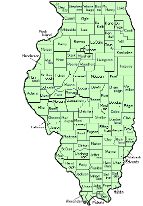 Here's
a nice
map of Illinois with all of the state's 102 counties listed and
named.
I am so familiar with Illinois that I can tell the validity of a lead
just
by remembering the relative location of counties, but I have done some
research in Texas in the past year or so and have to refer to a map
constantly.
There's a web site in my links page with the changes in Illinois
counties
listed which is really useful in developing migration patterns in the
state.
The area on the west side of the state--Madison and St. Clair
Counties--were
the first parts of Illinois to be settled, by the French.
Gallatin
and White were among the first counties settled in the eastern side of
the state, as they were natural gateways for people traveling down the
Ohio River or up from Kentucky, Tennesse and the Carolinas in the first
couple of decades of the 19th century. Settlers then moved
throughout the state, many times first starting towns along the
Mississippi
and Illinois rivers, and preferring hilly areas to the marshy and
unhealthy
prairies.
The Illinois Central railroad, built in the 1840s and 1850s, and the
Civil War, which made Chicago a major trading center, brought many
immigrants
from Europe and migrants from Ohio and eastern states. Railroads
and mining also added some unique groups of immigrants, such as the
Italians
to Herrin and the Poles to the Posen area. Many of the Germans
who
migrated to White County were from the Baden area, while the Irish
around
Enfield were from the old Queens County area but were joined by
immigrants
they met in the east and Cincinnati.
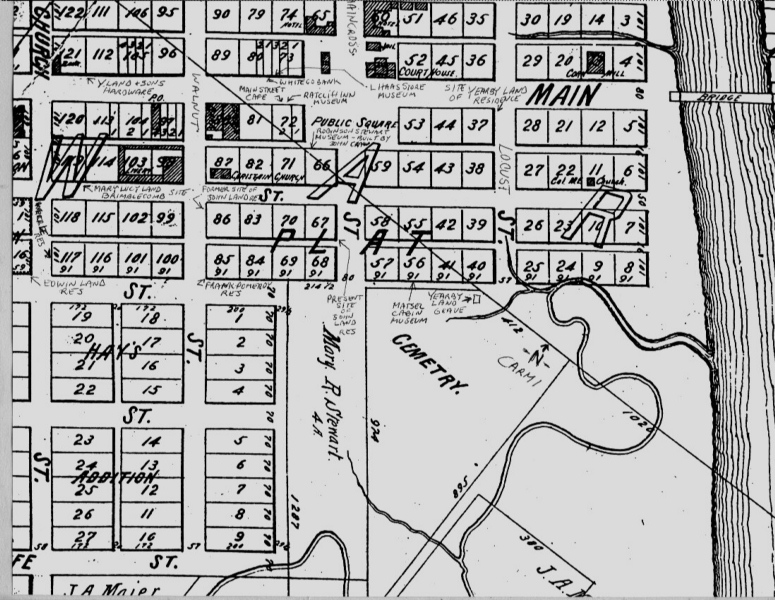
This is downtown Carmi from the 1901 Atlas with some modern
notations. I think they might have come from Jay Davis.
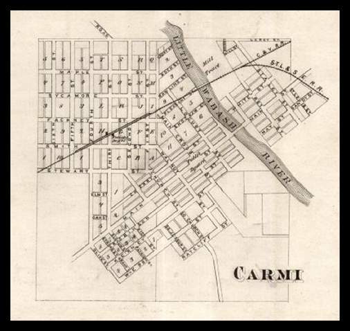 A plat of Carmi
from an 1870s map.
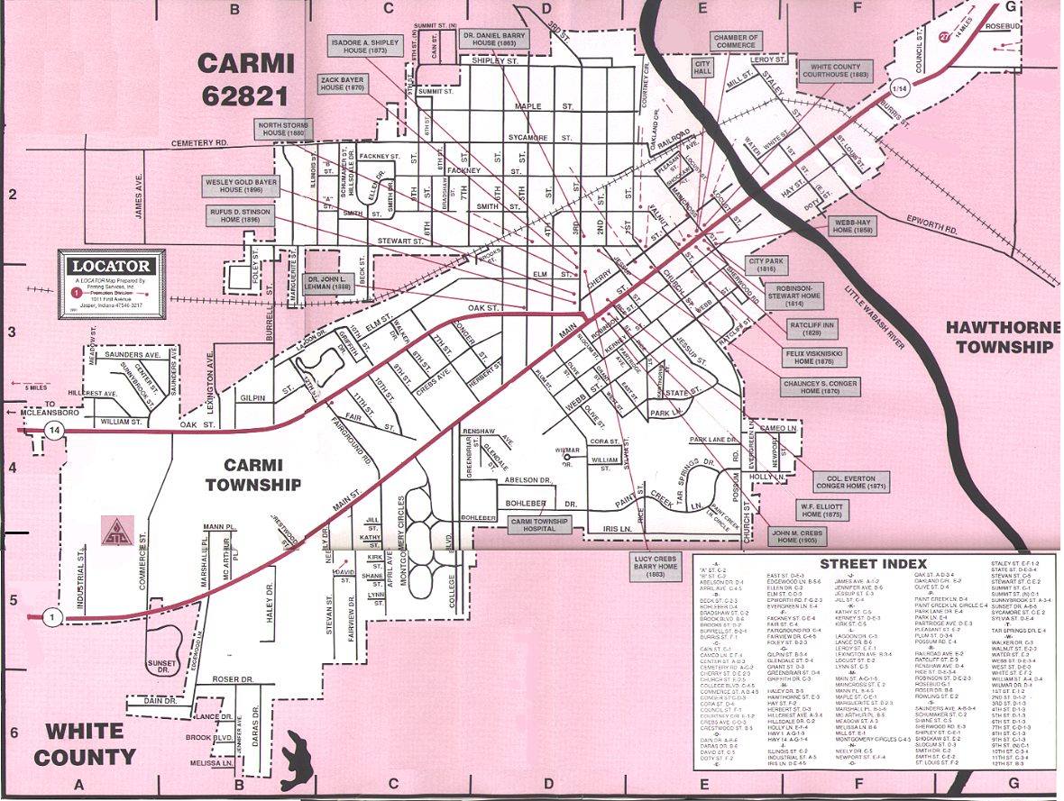
This map is really big, but has many notations of historic homes and
other places. I guess it comes from around 1990.
Updated by Cindy Birk
Conley,
8/7/2011
Copyright ©1998, 1999, 2000 by
Cindy
Birk Conley, all rights reserved. For
personal use only. Commercial use of the
information
contained in these pages is strictly prohibited without prior
permission.
If copied, this copyright notice must appear with the information.


 Here's
a nice
map of Illinois with all of the state's 102 counties listed and
named.
I am so familiar with Illinois that I can tell the validity of a lead
just
by remembering the relative location of counties, but I have done some
research in Texas in the past year or so and have to refer to a map
constantly.

 A plat of Carmi
from an 1870s map.

